Ringing and Wing tags
Finding vulture nests in an area the size of a small European country is not easy but in 2001 a major breakthrough was achieved when a light aircraft was used to conduct a survey to find breeding birds - at the end of the survey 42 nests had been found. Aeroplanes have been used to find the nests ever since, before ringing of the chicks is started. The huge nests can easily be spotted from the air and, thanks to modern technology, are recorded on a GPS device. Using aerial surveys not only saves time - to survey the park usually takes about three days - but it also prevents unnecessary off-road driving in a very sensitive environment. All the survey data is collated and the team then proceeds by vehicle from nest to nest.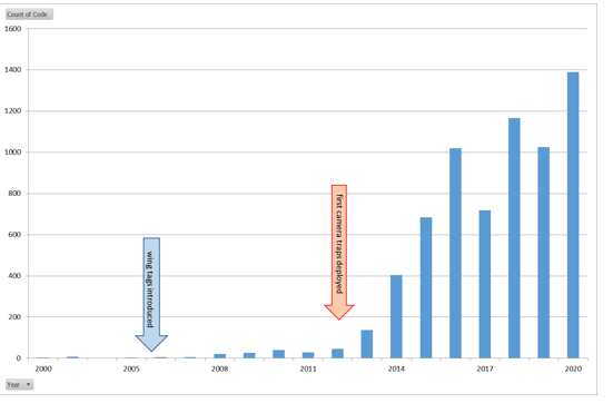
Number of tag re-sightings per annum.
Satellite Tracking
Re-sightings of wing tags are very useful but they do not tell us anything about the movement of the bird between the point where the tag was fitted and where it was re-sighted. This is where tracking devices come in very handy. Tracking devices are basically a GPS device that sends positions via satellite or GSM (cell phone) network. They are mounted like a small backpack to the birds using a strong Teflon tape harness. Thanks to generous donations we were able to purchase several of these devices and fit them to chicks, just before they fledged, in 2018 and 2019. The results are incredible: two birds from 2018 have already travelled more than 40 000 km each, reaching speeds of over 100 km/h and altitudes of more than 3000m above sea level (that is higher than Namibia's highest mountain, the Brandberg!). Collecting all this tracking data will allow us to find areas where the vultures spend a lot of time and that, in turn, will give us an opportunity to ensure that those particular places are safe for vultures to use (See here).
L795, nicknamed John Travulture (or more correctly Joan Travulture!), sponsored by Reptile Uranium, was fitted with her satellite tag in early December 2018. This was a nestling whose nest was in the Namib-Naukluft Park near Gemsbokwater. L763, Ricoffy, sponsored by Two Beards Coffee Roasters, also received her tag in early December as a nestling near Elim Farmhouse in the Namib-Naukluft Park. After fledging they first explored the area around their nests, gradually becoming independent of both the nest site and parents.
During this time L763 and L795 have travelled over 56,500 Km and 61,700 Km respectively
The animation below shows their movement over two years.